Coloring Within the Lines


To maintain the integrity of a supplied drawing, people usually color as much as they can within the lines. Some people use crayons, while others use markers or pens. When it comes to using electromagnetic spectrum in the United States, the National Telecommunications and Information Administration (NTIA) is in charge of allocating bands within the spectrum and making sure everyone stays within their specified lines. The NTIA does its work within the Department of Commerce.


The Department of Commerce also oversees the National Oceanic and Atmospheric Administration (NOAA), which in turn oversees the National Weather Service (NWS). Independent of all these Department of Commerce agencies is the Federal Communications Commission (FCC), which regulates the parts of the spectrum allocated for its oversight by the FTIA, such as radio, television, and cellular phone frequencies. Beginning late last year, the FCC has been auctioning spectrum to mobile phone companies for them to use in their 5G networks. When the FCC auctioned off spectrum in the 24GHz (gigahertz) band, they raised alarm within the NOAA since that agency uses the 23.8GHz band in its weather satellites to measure water vapor in the atmosphere, a key component in its ability to forecast the weather.

January 2016 Spectrum Wall Chart
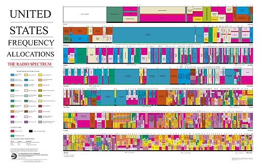
This image of an outdated January 2016 Spectrum Wall Chart from the NTIA is only useful as an overview of just how tightly packed bandwidth allocation is in parts of the spectrum, based on the jumble of colors. For a better view, download a PDF (Portable Document Format) of the chart from the NTIA website, though even then it can be a strain on the eyes without higher magnification.

Now anyone who has ever manually tuned a radio receiver with a dial knows the radio stations do not stay exactly within their spectrum lines at all times, and depending on the power of the transmitters the different stations use and atmospheric conditions and the varying state of the ionosphere, some stations can occasionally push into the territory of other stations. That is what worries NOAA administrators about the 24GHz band proposed for 5G use by mobile phone companies and their man in the FCC, Chairman Ajit Pai. NOAA administrators believe 24GHz is too close for comfort and may occasionally interfere with its use of 23.8GHz, which it cannot change because it is determined by the physical law of water vapor’s behavior. They believe the interference could cause as much as a 30 percent drop in forecasting efficiency, akin to stepping back in time to 1980.

This inter agency squabble isn’t even necessary, it turns out, because if the FCC and American mobile phone companies followed the European model for ensuring minimal interference with weather satellites, they would simply add greater restrictions to the transmitting power of 5G antennas in the higher bandwidths and rely more extensively on mid-range bandwidths that are not only better for 5G transmission, but also safely removed from the vicinity of crucial weather data transmissions.

A May 2019 news report from Sky News in London, England.

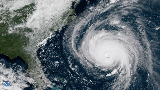
There will be a World Radiocommunication Conference in Egypt in October and November, where attendees will set international standards for 5G. Considering the attitudes and policies of the current presidential administration, the American delegation will probably resist the European model and go its own incautious way in order to serve the interests of the major telecommunications companies. It’s possible the American model may turn out fine eventually, but considering the drawbacks of being wrong, wouldn’t it be prudent to heed the concerns of weather forecasters, at least until more field testing proves without a doubt the safety of using the 24GHz band of the spectrum? To satisfy the greed of telecommunications executives and the desire of some smartphone users for faster loading Facebook feeds, is it worth having a hurricane drop in on us unexpectedly? A real hurricane, that is, not one drawn with crayons, however neatly.
— Techly


Figure It Out for Yourself


Rush Limbaugh - Caricature (6965563089)
March 2012 caricature of Rush Limbaugh, by DonkeyHotey.

On Tuesday, September 11, as Hurricane Florence bore down on the southeastern United States, Rush Limbaugh spouted off once again on his radio program with his own ideas about hurricanes and climate change, much like he did last year when Hurricane Irma was bearing down on southern Florida. Last year, after cynically boasting of his skepticism over the forecast track and intensity of Irma, which he attributed to scare mongering by the political left, he hightailed it from his West Palm Beach estate in southern Florida to Los Angeles, California.

Presumably Florence does not threaten any of Mr. Limbaugh’s properties, and he has not made headlines for hypocrisy this time, but merely for being a dangerous loudmouth as usual. If Mr. Limbaugh remains skeptical of anthropogenic climate change and also thinks the hardworking forecasters at the National Hurricane Center (NHC) are in league with sellers of bottled water and other emergency supplies, then he should start doing his own weather forecasting and climate assessments using publicly available data from weather stations and satellites. He and his conspiracy theory acolytes would probably find other reasons to twist the facts to suit their beliefs, such as intimating the data were skewed by leftists, but it’s best not to go too far down the rabbit hole with them.

Hurricane Florence Nears the East Coast (43924103114)
In this satellite image from the National Oceanic and Atmospheric Administration (NOAA), Hurricane Florence nears the East Coast of the United States on Wednesday, September 12, 2018. West Palm Beach, home of Rush Limbaugh, is safely out of the way at the bottom left of the picture, near the southern tip of Florida.

It’s easier than ever to gather useful data from public sources in this, the Information Age. It’s easier, however, and apparently more profitable, to sit on your butt in the back of the class and shoot spitballs. It’s unfortunately likely that some people who heeded Rush Limbaugh’s lazy, reckless frothings on hurricanes and climate change are now coping with the destructive flood waters brought on by Hurricane Florence, which doesn’t care what he has to say.
— Vita


Stormy Weather


Hurricane Harvey, a category 4 storm at landfall in Rockport, Texas, on August 25, has moved on finally after causing catastrophic damage, mainly due to flooding, in southeastern Texas and southwestern Louisiana. Following on Harvey’s heels is Hurricane Irma, currently a category 5 storm entering the Caribbean Sea, with many Caribbean islands, large and small, in its sights as it makes its way to Florida later in the week. Beyond that Irma’s track is uncertain, and it could affect communities anywhere from the eastern Gulf Coast to the southern portion of the Eastern Seaboard.


With the various early warning detection systems in place today and improvements over the years in computer modeling of forecast tracks, predicted landfalls of hurricanes has become better than guesswork and moved on to science. Until the World War II era and the development of radar, detection of hurricanes and predictions about their track relied largely on observations made by knowledgeable shipboard weather watchers reporting to shore stations and the tracking by shorebound observers of weather systems that might influence a hurricane as it approached land. Early warning of hurricanes in the first half of the twentieth century was limited to a few days, with an uncertain track left up to guesswork until practically the day before landfall.

Hurricane Katrina Eye viewed from Hurricane Hunter (cropped)
View of the eyewall of Hurricane Katrina taken on August 28, 2005, as seen from a National Oceanic and Atmospheric Administration (NOAA) WP-3D Orion hurricane hunter aircraft before the storm made landfall on the United States Gulf Coast.

Before the twentieth century, prediction of hurricanes was further limited to personal observations of weather conditions as the storm approached, because ships at sea were largely driven by wind power and were not as likely as coal, steam, or oil powered ships of later times to arrive in port well ahead of a storm and warn of its approach. People relied on observations of certain types of clouds and of the drop in barometric pressure, however they measured it, to give them indications of an approaching storm. Residents along the shore might have a day or two warning to head inland for higher ground. Absolute amount of fatalities could be high during the storm because of the short notice, but values of property damage were low because there were fewer people living along the coast and because they had not invested millions and billions of dollars in homes, hotels, and infrastructure to be destroyed.


Hurricane warning (USA)
USA hurricane weather warning flags. Drawing by Herostratus.

That formula has been steadily turned upside down through the twentieth and twenty-first centuries. Property damage amounts from hurricanes have skyrocketed due to the enormous increase in development close to the sea, while fatalities in proportion to total population have dropped dramatically due to warning times of several days to a week or more. Even if people do not evacuate the area entirely, they have sufficient warning time to load up on supplies and defenses to help them weather the crisis in place. In the past, shore residents did not have that luxury. To find a similar situation today of short warning of dangerous weather contributing to high fatalities, one would have to look at tornadoes, a highly localized phenomena when they do crop up.

No one who has ever survived the experience of a hurricane or a tornado or other severe weather disaster can ever dismiss the further possibility of such events lightly. They know in their guts how frightening and life-changing those events can be. The poor especially, as they do in all things in life, suffer disproportionately. The poor cannot afford to flee to higher ground. The houses the poor live in, where they might choose to shelter in place in order to ride out storms, are often flimsily constructed and the first to be destroyed by high winds or high water. Tornadoes are not magically drawn to trailer parks, it’s just that there is where the damage happens that draws the rubberneckers running the local television news stations.

We live in an age when severe weather events are becoming more common, regardless of whether or not an ideologically motivated minority continues to argue the point without reference to facts. Preparing for severe weather, however, has never been a better proposition for most of humankind over what it was in past generations. Ironic that our reliance on technology, which has brought us to the brink of climate destruction, could also serve to save us from its worst effects, at least in the short term.
― Vita